CAPTURE EXISTING CONDITIONS
3D Laser Scanning Boca Raton, FL
Looking for professional 3D laser scanning in Boca Raton? We provide building scanning services for residential, historic, and commercial properties. Our technology captures detailed existing conditions to support architectural documentation, renovations, and Scan-to-BIM workflows.
THE SERVICE
What does building laser scanning capture?
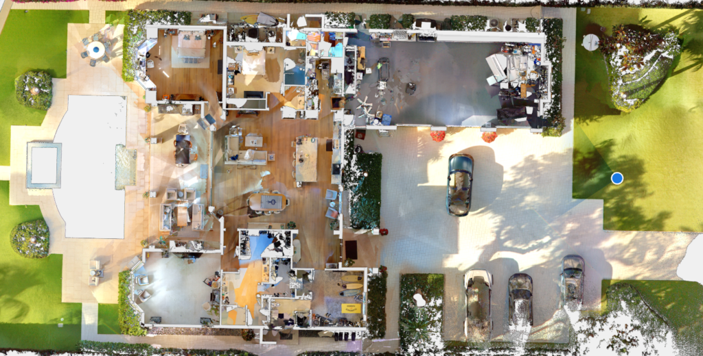
Terrestrial 3D laser scanners collect millions of measured points from visible surfaces. After individual scan positions are aligned, the resulting registered point cloud can document the shape and spatial relationships of floors, walls, ceilings, columns, stairs and exposed equipment.
A scan is not automatically a finished CAD drawing or BIM model. The point cloud is source data that can be used to create as-built drawings, a Revit model or another agreed deliverable. What is captured depends on line of sight, access, site conditions and the requested scope.
Laser scanning does not see through walls or verify hidden utilities. If parts of the site are inaccessible or obstructed, those limitations should be recorded rather than guessed away.
PROJECT OUTPUTS
What should you expect to receive?
Common outputs from a scanning project include a registered point cloud, an agreed scan-data format such as E57, site-view imagery where available, and optionally 2D plans or 3D models derived from the scan. Deliverable formats and registration requirements should be confirmed before field work starts.
What to include in your quote request
- Areas and levels to scan, including roof or exterior access where needed
- Whether the team needs a point cloud only or additional CAD / BIM deliverables
- Target dimensional tolerances, control requirements and intended use
- Site restrictions: occupancy, reflective surfaces, narrow rooms or restricted areas
COMMON USES
When 3D laser scanning is a good fit
Renovation design: build a more reliable baseline before layout or equipment changes.
Construction coordination: share measured geometry with consultants who work in different systems.
Facility documentation: capture current spaces for later planning or maintenance reference.
Complex interiors: record visible equipment and building geometry that is cumbersome to measure manually.
HOW PROJECTS WORK
A clear scope leads to a more useful deliverable
01. Describe the goal
Explain what the files will be used for and which building areas matter.
02. Confirm inputs
Review available plans, scan data, access needs and source limitations.
03. Agree on outputs
Define deliverable format, model/drawing detail, timing and review scope.
04. Review the result
Check the agreed files against the project scope and note open questions.
LOCAL SERVICE
3D Laser Scanning Boca Raton projects
Boca Raton projects can range from office renovations and retail spaces to residential remodels and multi-tenant properties. For each property, the best capture plan depends on access, building size, what is visible and which downstream drawings are required. Describe your site rather than choosing scanner specifications yourself.
FREQUENTLY ASKED QUESTIONS
3D Laser Scanning Boca Raton FAQs
How accurate is a 3D laser scan?
Accuracy depends on equipment, scan registration, control, surface conditions and the project scope. Ask for the proposed method and tolerances rather than assuming one universal accuracy number.
Do I receive a Revit model automatically?
No. A laser scan produces measured data; Revit modeling is an additional scope of work that converts relevant geometry into modeled building elements.
Can an occupied building be scanned?
Often yes, but people and movable objects can obstruct measurements. Access windows and operational constraints should be discussed first.
What is a point cloud?
A point cloud is a collection of measured 3D positions representing visible surfaces. It can be viewed directly or used as a reference for CAD or BIM production.
TECHNICAL READING
A reference for your project team
For readers who want software-specific information, here is relevant technical documentation from Autodesk. This is external documentation, not an endorsement or statement of affiliation.
Get the right files for your project
Not sure whether you need a point cloud, an as-built plan or a Revit file? Tell us the project goal and existing information. The right deliverable can be discussed before any work is promised.